Peru & Ecuador
Watch eastern Pacific sea temperatures and local seasonal outlooks for coastal rainfall risk.
Moisture, cold air & flooding
The winter being watched · 2026–27
What makes a wet winter dangerous?Warm, moist air, an influx of cold, and a stalled storm track can combine to bring prolonged rain, ice, or snow.
How the pieces connect
Flooding needs more than moisture. It needs a way to lift that moisture—and weather that keeps bringing it back.
El Niño can influence the storm track and moisture supply. A weakened polar vortex can influence the movement of Arctic air. When moist air rises over colder air beneath a persistent weather pattern, precipitation can fall over the same ground for days. Where it lands depends on the circulation, terrain, and temperatures.
01 / Sequence
Moisture supplies the water. Circulation brings the air masses together. Persistent lifting produces rain or snow. Coastal water levels can make drainage harder.
Original concept artwork. Its dated figures and record claims remain unverified; see the reports and qualifications below.
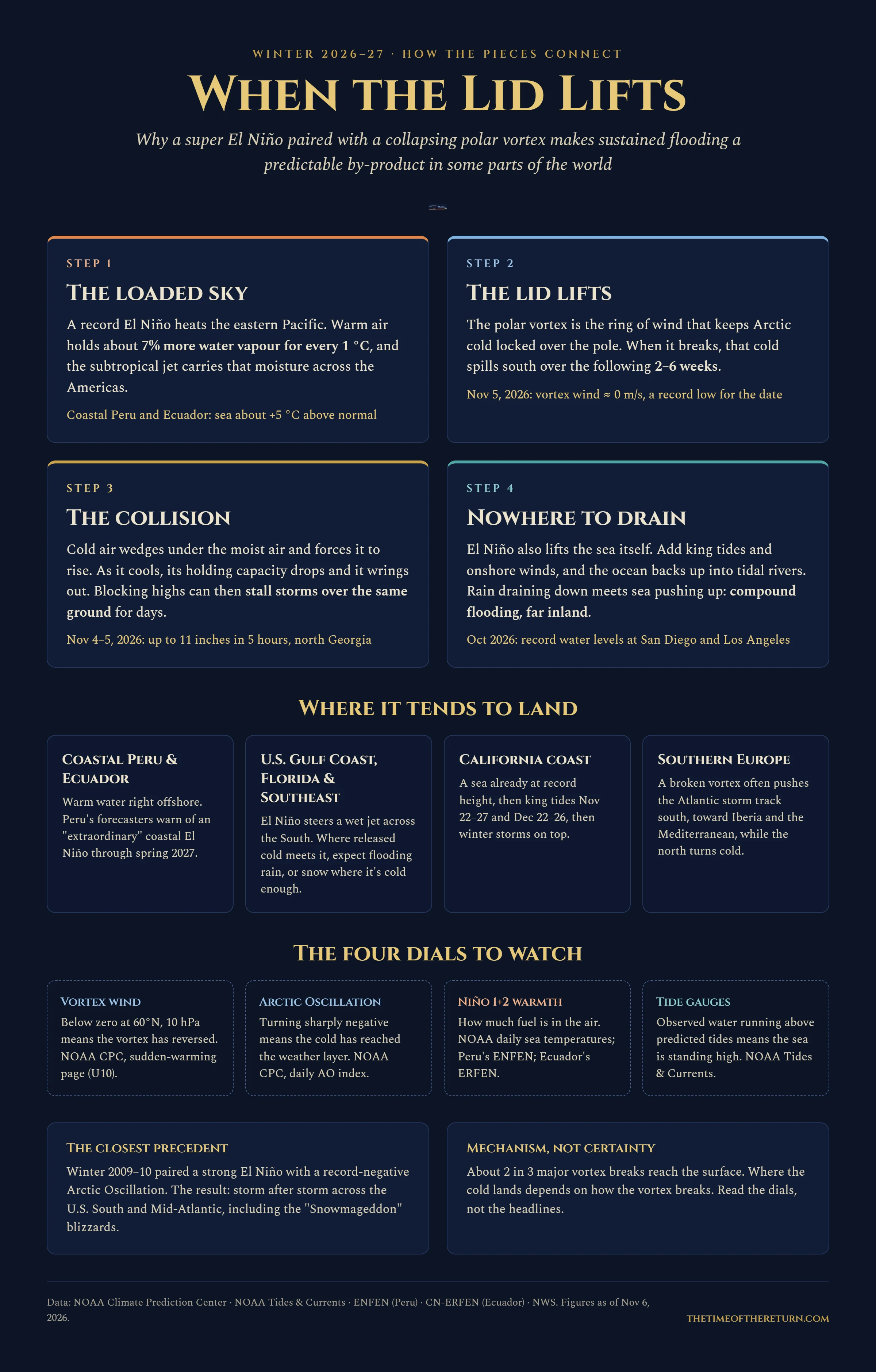
Watch eastern Pacific sea temperatures and local seasonal outlooks for coastal rainfall risk.
Watch for repeated storms along the same track, saturated soils, and cold air reaching the moisture plume.
Watch Pacific storm forecasts alongside tide and surge forecasts, especially where rivers meet the sea.
Watch Atlantic blocking and storm-track forecasts for persistent rain around Iberia and the Mediterranean.
These are regional watch points, not a forecast of affected areas.
02 / Observe
Check the latest readings at these sources.
At 10 hPa and 60°N, a reversal of the zonal-mean winds is a key sign of a major midwinter warming. Surface effects can develop over subsequent weeks, but not every disturbance brings a cold outbreak.
NOAA CPC · stratosphere ↗A negative AO can favor high-latitude blocking and exchanges of cold and warm air. Read it alongside regional forecasts.
NOAA CPC · daily AO index ↗Check ENSO status, eastern Pacific sea temperatures, and seasonal outlooks for changes in likely storm tracks.
NOAA CPC · ENSO advisory ↗Compare observed water levels with predicted tides. Water running above prediction can indicate an added contribution from wind, pressure, or other local conditions.
NOAA Tides & Currents ↗03 / Mechanics
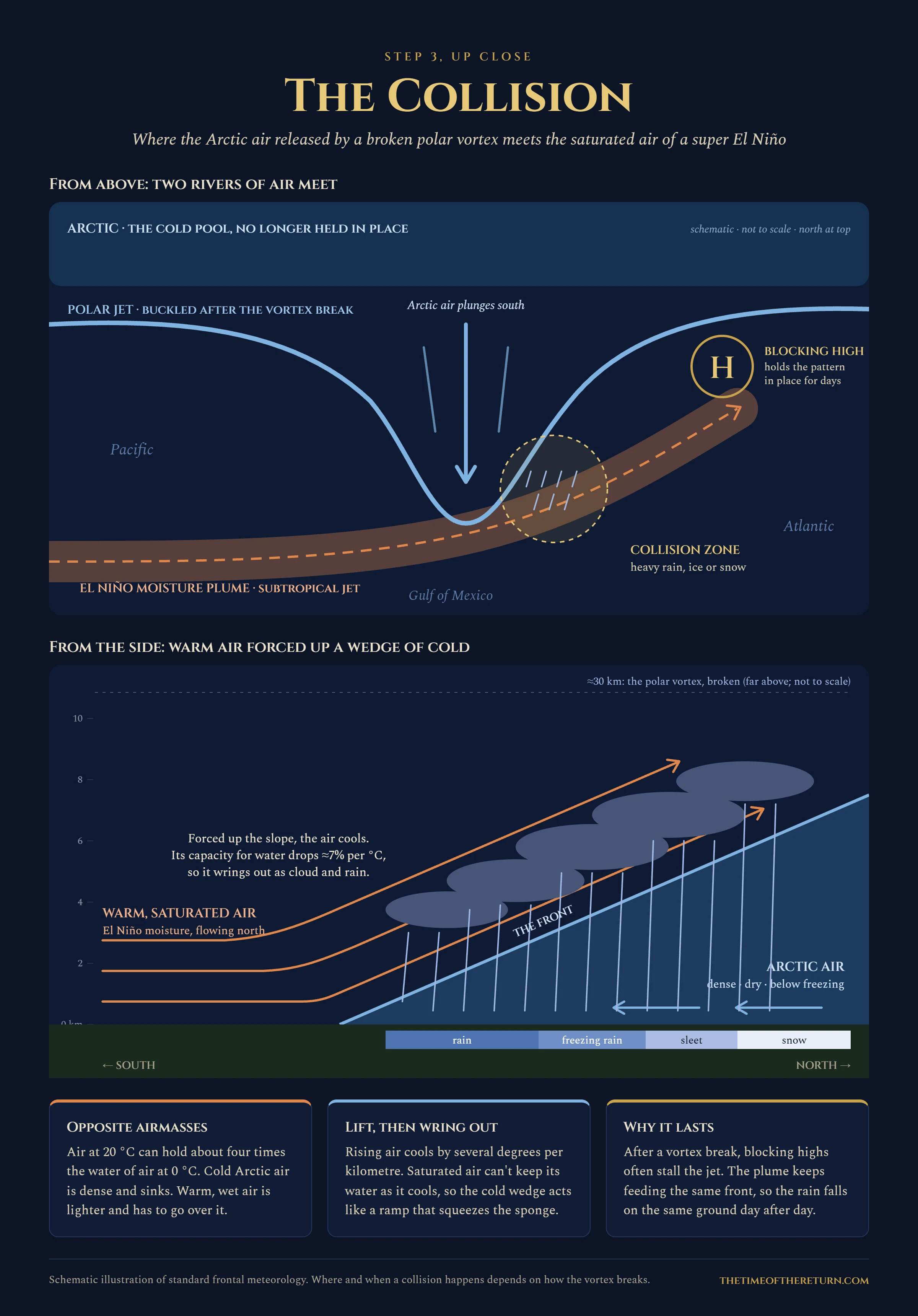
Top view: North is at the top; the cold Arctic region lies northward. The blue polar-jet line dips south, while orange subtropical moisture crosses toward the Atlantic. Their overlap marks the potential precipitation zone. A blocking high to the northeast can slow the pattern.
Side view: South is on the left and north on the right. Warm, moist air rises over a cold wedge, expands and cools; if it reaches saturation, water vapor condenses. The type of precipitation—rain, freezing rain, sleet, or snow—depends on the full vertical temperature profile, not latitude alone.
The stratospheric vortex, roughly 30 km above Earth, lies well above the fronts and polar jet that organize surface weather. The diagram combines these levels schematically; it is not to scale.
Near typical surface temperatures, saturation vapor pressure rises roughly 7% per °C. That is a relationship for air’s moisture-holding capacity, not a direct increase in rainfall. Actual rainfall depends on the moisture supply, lifting, and storm duration.
Schematic, not to scale. Blocking is one possible pattern; precipitation type depends on temperatures through the air column.
04 / Dated record
Assessment date · 6 November 2026
A WLOS report published November 5 describes more than 11 inches of rain in north Georgia overnight November 4–5, including 11.19 inches near Blue Ridge in less than six hours. It also reports an 18.05-foot river crest.
Read the WLOS report ↗WLOS cites NWS figures. This flood has not been attributed to the reported vortex disruption.Fox Weather’s November 6 report describes an early disruption, while saying a major breakdown remains conditional.
Read the Fox Weather report ↗NOAA Climate.gov · moisture and heavy precipitation ↗
Moisture and heavy-rain potential.
NOAA repository · extreme rainfall and atmospheric water balance ↗
Saturation, moisture transport, and storm dynamics.
NOAA Climate.gov · El Niño and the stratospheric polar vortex ↗
How the tropical Pacific can influence the stratosphere.
NOAA Climate.gov · El Niño and La Niña FAQs ↗
ENSO’s regional climate influences.
NOAA CPC · stratospheric monitoring ↗
Stratospheric circulation charts.
NOAA CPC · ENSO advisory ↗
Official ENSO discussion and status information.
The Last Winter explores the house’s proposed ancient chronology and its 2026–27 echo. That prophetic interpretation is separate from the weather mechanisms described here.